Air pollution in the United States has declined dramatically over the last several decades, thanks to strong, protective clean air policies. And yet, unjust disparities in pollution exposure remain, with people of color in the United States burdened by higher levels of health-harming pollution than white people, regardless of income.
One cause of these pollution inequities is the historic legacy of disinvestment in communities of color through racist policies like redlining, along with discriminatory siting of highways and polluting industrial facilities. This results in health disparities and higher vulnerability to the health impacts of air pollution for people who live, work and play in close proximity to its sources.
Neighborhood-scale air quality data can provide a clearer picture of air pollution’s impacts
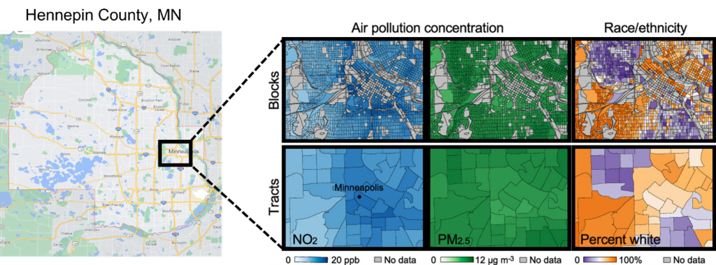
Air quality is often evaluated at the city or county scale, but pollution levels vary at a much finer scale, as do the demographics of neighborhoods shaped by residential segregation.
New legislation recently introduced to Congress would require the U.S. Environmental Protection Agency to advance development of hyperlocal air quality monitoring systems that will provide better, more localized data on pollution hotspots and inequity in pollution exposure. Importantly, the bill calls for monitoring “at a geographic scale that is (i) as small as practicable to identify communities; and (ii) not larger than that of a census tract.”
Why is this issue of geographic scale so important? The scale at which data is collected and analyzed can have major impacts on our understanding of pollution disparities. New research from EDF and partners explored whether it is possible to accurately estimate disparities in exposure to air pollution using larger scale data (for example, county averages) or whether finer scale data (census tract or smaller) is needed.
We found that for two important health-harming pollutants, fine particulate matter (PM2.5) and nitrogen dioxide (NO2), using state and county scale data led to substantial underestimates in US-wide racial/ethnic exposure disparities compared to those based on finer scale data—on average, using country vs. tract data would underestimate national exposure disparities by 20%.
Within individual cities, while census tract scale data was often adequate to characterize disparities, it was sometimes necessary to use even finer data – as small as a city block— to capture the full magnitude of inequity across neighborhoods.
This research adds further evidence to support what environmental justice advocates have long been telling policymakers: in order to identify the people and communities most exposed to harmful pollution, we need data and analysis at the scale of individual neighborhoods.
Data can direct funding to communities with the greatest need
Air pollution can vary across communities–even from block to block–and more data is needed to understand where air pollution comes from, who it’s impacting and who’s responsible for it. This is critical to reduce disparities in pollution exposures throughout the U.S.
EPA’s recent announcement of $53m in new funding for community-level air quality monitoring is a powerful step in support of the Justice40 Initiative, a federal commitment calling for our nation’s most overburdened communities to be prioritized for investment and reductions in pollution. Continued advancements in hyperlocal monitoring and analytical methods will help accurately identify those places, track progress and hold our institutions accountable for eliminating inequities in exposure to health-harming pollution.